Refineries and petrochemical facilities are using unmanned aerial vehicles (UAVs) or drones to minimize worker exposure to unnecessary hazards and reduce the costs of inspections. These same benefits can be realized for air pollution testing and other air quality measurements in plant locations that are difficult for humans to access. CleanAir uses an open-path Active Fourier Transform Infrared Spectroscopy (AFTIR) system with a drone to measure speciated concentrations of gas plume components from stacks, flares, and other difficult to access locations.
Historically, AFTIR measurements have been used for fence line studies and other measurements taken at fixed locations. Coupling an AFTIR analyzer with a drone helps us collect AFTIR measurements at a variety of location types. When coupled with Infrared Remote Velocity Measurement technology, this technique can be used to determine mass emission rates.
CleanAir Case Study
CleanAir first ventured into the remote measurement world to measure flare destruction efficiency, which can be calculated from the composition of a flare plume. For most industry-sponsored flare tests, we used a Passive Fourier Transform Infrared Spectroscopy (PFTIR) system to measure destruction efficiency. PFTIR was chosen because it is a good technology for remotely measuring the composition of hot gas plumes (like those from a flare), but a limitation of PFTIR is that it cannot see colder gas plumes.
Many environmental applications require remote speciation of gas plumes that are not hot enough for PFTIR. As an example, CleanAir needed to measure destruction efficiency of an enclosed flare, but the enclosure prevented us from measuring the gas before it cooled to the point where PFTIR could not be used. So, CleanAir coupled an AFTIR system with a drone to analyze pollutants in on this high, inaccessible stack. A retroreflector array was suspended from a drone hovering behind the emission plume relative to the AFTIR about 100 feet in the air.
How it works
The AFTIR uses an optical telescope to transmit an infrared (IR) beam through the gas plume. The IR beam is reflected back to the analyzer by a retroreflector array suspended from the drone where the absorption of the IR radiation is used determine the composition of the gas in the measurement region. The AFTIR does this by measuring how much of the reference IR beam is absorbed by gases at various IR wavelengths.
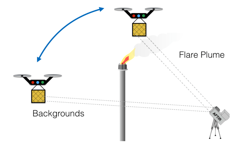
AFTIR has been used for remote stack emissions measurements in the past, but a stationary placement of a retroreflector array presents challenges. This is because many gas emission plumes are constantly moving. Using CleanAir’s configuration of AFTIR with a drone, we can continuously move the drone and adjust the AFTIR analyzer to stay focused on the plume during testing and quickly move to a clear area of the sky for background readings as required.
Using this technique, we can theoretically measure anything that an FTIR can detect (including CO2, SO2, NOX, CO, and more). Like all FTIR applications, the detection limits for each measured compound will vary by use case (compounds measured, distance between drone and AFTIR, etc.).
This is a complex test procedure that is still in its infancy. So, it isn’t used for routine monitoring and testing yet. Currently, this technique is best suited for hazardous or inaccessible sampling locations, but remote measurements are becoming more common. This is just the beginning of using drones for air pollution testing.
Related posts


Don Walker
February 16, 2021 at 1:31 PMGood write up. Suggest including some actual testing results for different gases and PPM measurements. Add contact info for parties to use who are interested in more data. Talk to management about reduced price for initial test trial.